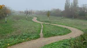
there’s an “official” mapped bike/walk path that joins the street 200m away. It passes through a park and a creek. From the traces what i assume is that after riding between trees and on a path, people don’t want to get down to the street but just continue riding/walking on the grass (which no longer is grass).
I love desire paths but i really couldn’t understand this one. I’ve seen more interesting ones in that area, i just need a break from the rain to have the courage to stop and take photos.
i thought i’ve found a shortcut but the street curves away from my commute. I may go back on a sunny Sunday.
Looks like a rich suburb that can influence decision makers to privatise the circulation by having multiple dead-ends. If a car is there, they’re either lost or they live there.